What Is a Digital Twin and Why It Matters for Modern Cities and Infrastructure
Cities and infrastructure networks are under mounting pressure from aging assets, population growth, climate volatility, and rising service-level expectations. Traditional management approaches—based on periodic inspections, static design models, and reactive maintenance—are increasingly inadequate for the complexity and pace of modern urban systems.
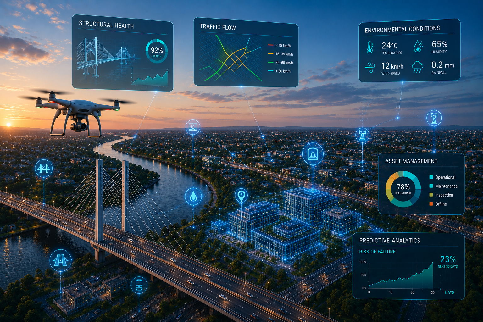
The digital twin has emerged as a foundational technology for addressing these challenges. A digital twin is not simply a 3D visualization; it is a continuously synchronized, data-driven virtual representation of a physical asset, system, or environment that supports real-time monitoring, simulation, and predictive decision-making.
By integrating geospatial survey data, IoT sensor feeds, engineering models, and advanced analytics into a single coherent platform, digital twins enable infrastructure operators and city managers to understand current conditions, model future scenarios, and optimize performance across the full asset lifecycle—from design and construction through operation, maintenance, and eventual decommissioning.
This article examines the architecture, operational principles, and strategic value of digital twins for infrastructure and smart-city applications, and outlines the key considerations for successful implementation.
What Is a Digital Twin?
A digital twin is a virtual replica of a physical asset, system, or environment that is continuously updated with real-world data to maintain an accurate, current representation of its physical counterpart. Unlike static 3D models or conventional BIM datasets, a digital twin is a living system that evolves in step with the asset it represents.
Defining Characteristics
- Real-time synchronization — the digital model reflects the current state of the physical asset, not a design-stage snapshot
- Temporal continuity—the twin accumulates historical data, enabling trend analysis and lifecycle tracking
- Simulation capability—users can run "what-if" scenarios, stress tests, and predictive models against the twin
- Bi-directional feedback—insights derived from the digital twin can trigger actions or alerts in the physical environment
Core Architecture
A functional digital twin comprises four interdependent layers:
- Physical Asset Layer — the real-world infrastructure element: a bridge, a building, a utility network, a transportation corridor, or an entire city district.
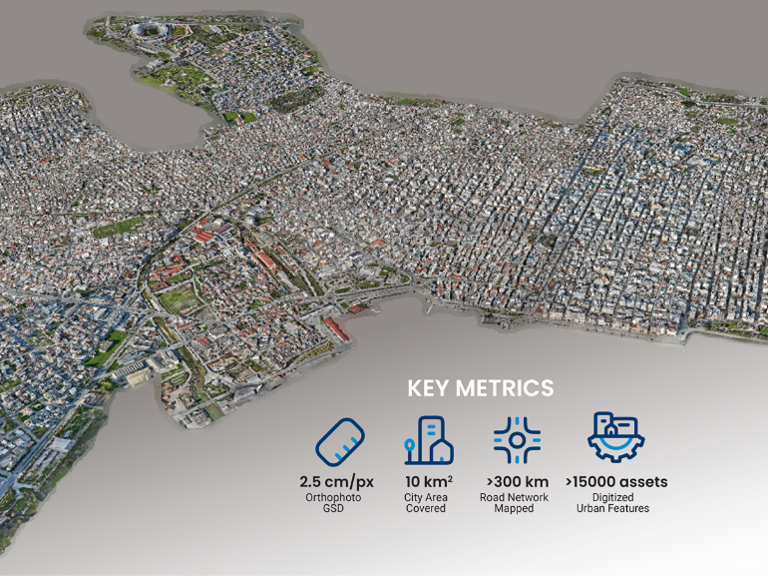
- Digital Model Layer — the geometric and semantic representation of the asset, typically derived from survey-grade geospatial data (LiDAR, photogrammetry, BIM) and enriched with attribute data such as material properties, design specifications, and maintenance history.
- Data Integration Layer — the middleware that ingests, normalizes, and routes data from heterogeneous sources: IoT sensors (structural strain, temperature, vibration, flow rates), SCADA systems, GIS databases, weather services, traffic management systems, and manual inspection records.
- Analytics and Decision Layer — the computational engine that processes integrated data to generate actionable intelligence: real-time condition dashboards, physics-based simulations, machine-learning predictions, and automated alert workflows.
How Digital Twins Work
The operational cycle of a digital twin follows a structured sequence of data acquisition, integration, synchronization, and analysis:
1. Data AcquisitionThe foundation of any digital twin is a high-fidelity spatial baseline. This is typically established through:
- UAV-based photogrammetry and LiDAR for survey-grade 3D geometry and terrain models
- Terrestrial laser scanning for high-detail interior or structural surveys
- Satellite and aerial imagery for broad-area contextual coverage
- BIM and CAD data from the design and construction phases
- IoT sensor networks for continuous operational data (structural health, environmental conditions, utility flows)
2. Data Integration and NormalizationRaw data from diverse sources arrives in different formats, coordinate systems, and temporal resolutions. The integration layer harmonizes these inputs into a unified data model, typically combining:
- GIS platforms for spatial referencing, thematic mapping, and multi-layer analysis
- BIM environments for design-stage geometry, component metadata, and construction records
- Cloud-based data platforms for scalable storage, real-time streaming, and API-driven interoperability
- Time-series databases for sensor telemetry and historical trend analysis
3. Real-Time SynchronizationLive data streams—from IoT sensors, SCADA systems, traffic feeds, and weather APIs—continuously update the digital twin so that it reflects the actual condition of the physical asset at any given moment. Synchronization intervals range from sub-second (for critical structural monitoring) to hourly or daily (for environmental or planning applications), depending on the use case and the required decision-making tempo.
4. Simulation, Analysis, and Decision SupportThe analytics layer transforms integrated data into actionable intelligence:
- Physics-based simulation — structural load modelling, hydraulic flow analysis, thermal performance assessment
- Scenario modelling — "what-if" analysis for design changes, capacity expansion, policy interventions, or extreme-event response
- Predictive analytics — machine-learning models that forecast equipment failure, pavement degradation, or demand patterns
- Automated alerting — threshold-triggered notifications that enable proactive intervention before failures occur
Why Digital Twins Matter for Modern Cities and Infrastructure
Digital twins address a fundamental challenge in infrastructure and urban management: the gap between the volume of available data and the ability to extract timely, actionable insight from it. By structuring data around a spatial and temporal model of the physical world, digital twins transform fragmented information streams into coherent operational intelligence.
1. Evidence-Based Urban PlanningUrban planners can model the impact of proposed developments, zoning changes, transportation investments, and policy interventions before committing resources. By simulating population growth scenarios, traffic redistribution, service-demand projections, and environmental effects within the twin, decision-makers can evaluate alternatives with greater confidence and transparency.
2. Predictive and Condition-Based MaintenanceRather than relying on fixed-interval inspection schedules, infrastructure operators can use digital twins to monitor asset condition continuously and schedule maintenance based on actual deterioration trends. This approach extends asset life, reduces unplanned downtime, and directs maintenance budgets where they deliver the greatest impact.
3. Faster, More Informed Decision-MakingBy consolidating operational data, spatial context, and analytical tools in a single environment, digital twins compress the time between data collection and decision. Emergency managers responding to a flood event, traffic engineers optimizing signal timing, or utility operators managing grid load all benefit from having a current, queryable model of their system.
4. Sustainability and Environmental PerformanceDigital twins support environmental objectives by enabling continuous tracking of energy consumption, carbon emissions, water usage, and waste generation at asset and district scales. Simulation capabilities allow operators to model the impact of efficiency interventions—such as building retrofits, renewable-energy integration, or green-infrastructure deployment—before committing capital.
5. Risk Assessment and Resilience PlanningBy combining terrain models, structural data, climate projections, and real-time sensor feeds, digital twins enable quantitative risk assessment for natural hazards (flooding, seismic events, extreme heat), infrastructure failure scenarios, and cascading system interdependencies. This supports both proactive resilience planning and real-time emergency response.
Applications Across the Infrastructure Lifecycle
Urban Planning and Development
- Scenario testing for zoning, density, and land-use decisions
- Visual-impact assessment and stakeholder consultation
- Infrastructure capacity modelling for proposed developments
Transportation Systems
- Traffic-flow simulation and signal optimization
- Multimodal transportation planning and demand modelling
- Corridor management for road, rail, and transit networks
Environmental Monitoring
- Air-quality tracking and source-apportionment modelling
- Flood-risk analysis using real-time hydrological data and terrain models
- Urban heat-island assessment and mitigation planning
Energy and Utilities
- Grid load balancing and demand forecasting
- Water-network leak detection and pressure optimization
- Renewable-energy integration and storage planning
Infrastructure Lifecycle Management
- Design-phase coordination and clash detection via BIM-integrated twins
- Construction progress monitoring against the as-designed model
- Operations-phase condition monitoring, predictive maintenance, and asset renewal planning
Digital Twins vs Traditional Models
The following table summarizes the principal differences between static engineering models and live digital twins:
| Characteristic | Traditional Models | Digital Twins |
|---|---|---|
| Data Currency | Static—reflects conditions at the time of creation | Dynamic—continuously updated with real-time data |
| Update Mechanism | Manual revision cycles | Automated sensor feeds and data pipelines |
| Analytical Capability | Limited to design-stage assumptions | Physics-based simulation, ML prediction, scenario modelling |
| Decision Support | Retrospective and design-focused | Real-time, predictive, and prescriptive |
| Lifecycle Coverage | Primarily design and construction | Full lifecycle—design through decommissioning |
| Stakeholder Access | Specialist tools, limited sharing | Web-based platforms, role-based dashboards |
Traditional models provide point-in-time snapshots. Digital twins provide continuous, evolving intelligence that supports decision-making across the full asset lifecycle.
Challenges and Implementation Considerations
While the strategic value of digital twins is well established, successful implementation requires careful attention to several technical and organizational factors:
- Data integration complexity — harmonizing data from IoT sensors, GIS databases, BIM models, SCADA systems, and manual inspection records into a coherent, interoperable data model
- Data quality and governance — establishing protocols for data validation, version control, access permissions, and lifecycle management to ensure the twin remains trustworthy
- Initial investment and business case — the upfront cost of sensor infrastructure, platform development, and data integration must be justified against quantified lifecycle benefits
- System interoperability — ensuring that the digital twin platform can exchange data with existing enterprise systems (ERP, CMMS, GIS, BIM authoring tools) through open standards and APIs
- Organizational readiness — the shift from document-centric to data-centric asset management requires changes in workflows, roles, and decision-making processes
- Scalability — architectures must accommodate growth from single-asset pilots to city-scale deployments without requiring fundamental redesign
Partnering with a provider that combines geospatial expertise, data-engineering capability, and infrastructure-domain knowledge is essential for navigating these challenges and delivering a digital twin that generates sustained operational value.
Integrating Digital Twins with Complementary Technologies
Digital twins achieve their full potential when integrated with complementary data-acquisition and analytics technologies:
- Drone mapping and reality capture — establishing and periodically refreshing the survey-grade spatial baseline that underpins the twin's geometric accuracy
- LiDAR and photogrammetry — providing dense, accurate 3D point clouds and photorealistic models for the digital-model layer
- AI and machine learning — powering predictive maintenance, anomaly detection, pattern recognition, and automated classification within the twin's analytics layer
- Custom software platforms — embedding digital-twin intelligence into bespoke operational dashboards, mobile field applications, and automated reporting systems
- GIS and BIM ecosystems — ensuring the twin interoperates with the spatial analysis and design-coordination tools already embedded in engineering workflows
The Return on Investment of Digital Twins
While digital twins require meaningful upfront investment in sensor infrastructure, platform development, and data integration, the return is realized through compounding operational efficiencies across the asset lifecycle:
- Reduced maintenance costs — condition-based and predictive maintenance strategies reduce unplanned interventions and extend the interval between major rehabilitations
- Extended asset lifespan — continuous monitoring and early intervention slow deterioration and defer costly replacements
- Improved operational efficiency — real-time visibility into system performance enables faster response, better resource allocation, and reduced energy consumption
- Enhanced risk mitigation — quantitative risk assessment and scenario modelling reduce the probability and financial impact of unplanned events
- Better capital planning — data-driven condition forecasting supports more accurate budget allocation and prioritization of capital renewal programmes
Organizations that adopt digital twins gain a structural advantage in managing complex infrastructure systems—not by acquiring more data, but by converting existing data into timely, decision-grade intelligence.
Why Choose ARGO-E
ARGO-E delivers end-to-end digital twin solutions engineered for infrastructure and urban environments. Our approach spans the full digital-twin lifecycle—from geospatial data acquisition and 3D model creation through data integration, analytics development, and operational deployment.
Our Capabilities
- Reality modelling and geospatial survey services using UAV, LiDAR, and photogrammetric platforms
- Data science and analytics—from sensor data pipelines to machine-learning models and predictive dashboards
- Software engineering and platform development—building the custom applications that embed digital-twin intelligence into your operational workflows
- Infrastructure-domain expertise—ensuring that the technical solution is grounded in engineering reality and aligned with your project objectives
We do not simply build digital models. We deliver the integrated intelligence layer that transforms spatial data into better engineering decisions.
Featured Project
|
|
Frequently Asked Questions
What is a digital twin?A digital twin is a continuously synchronized virtual representation of a physical asset, system, or environment. It integrates real-time sensor data, geospatial models, and analytics to support monitoring, simulation, and predictive decision-making across the asset lifecycle.
How are digital twins used in cities?Cities use digital twins for urban planning scenario modelling, infrastructure condition monitoring, transportation optimization, environmental performance tracking, emergency management, and citizen service delivery. The twin provides a shared spatial and temporal model that connects otherwise siloed city systems.
What are the benefits of digital twins?Key benefits include improved decision-making speed and confidence, reduced maintenance costs through predictive strategies, extended asset lifespans, enhanced risk management, better environmental performance, and more effective capital planning.
Are digital twins expensive to implement?Implementation requires upfront investment in sensor infrastructure, data integration, and platform development. However, the return is realized through compounding operational efficiencies — reduced unplanned maintenance, extended asset life, improved resource allocation, and better risk mitigation—that typically exceed the initial cost within the first few years of operation.
What data sources feed a digital twin?A digital twin ingests data from multiple sources: IoT sensors (structural, environmental, operational), UAV and LiDAR surveys, BIM and CAD models, GIS databases, SCADA systems, weather services, traffic management systems, and manual inspection records. The integration layer harmonizes these inputs into a unified, queryable data model.
ConclusionDigital twins represent a fundamental shift in how infrastructure and urban systems are designed, operated, and maintained. By creating a continuously updated, data-driven virtual representation of the physical world, they enable organizations to move from reactive management to proactive, evidence-based decision-making.
The technology is not a future concept—it is being deployed today across transportation networks, utility systems, building portfolios, and city-wide platforms. Organizations that invest in digital-twin capability now are building the information infrastructure that will underpin smarter, safer, and more sustainable operations for decades to come.
Ready to explore how digital twins can transform your projects?
Contact ARGO-E to design and implement a digital twin solution tailored to your infrastructure and operational needs.